Northern Michigan is under a “Use Extreme Caution” advisory from the Huron‑Manistee National Forests. Burn permits are suspended across much of the Lower Peninsula. And the fine fuels are drying by the hour. That isn’t a contradiction — it’s the pattern every fire service in rural America needs to plan around.
By Fred R. LaPoint
Fire Chief, Stronach Township Fire Department — Manistee County, Michigan
U.S. Coast Guard Veteran — TT2, Vietnam Era (1972–1976)
Disaster Responder with Team Rubicon with 30+ deployments
Licensed Paramedic | ICS 100–800
I’ve spent over fifty years doing this work. Career firefighter, paramedic, Coast Guard, and more than three dozen disaster deployments with Team Rubicon across the United States and internationally to Mozambique, Honduras, the Bahamas, and Mexico. Every one of those missions comes back to the same question that sits underneath all the tactical decisions: can we get there, and can we get back out?
This spring, that question is sitting right on top of my desk. And if you’re reading Behind The Alarm from anywhere else in rural America, I’d bet it’s sitting on yours, too.
The Northern Michigan Picture
As of this writing, the Huron‑Manistee National Forests remain under an active “Use Extreme Caution — Know Before You Go” advisory. The cause is historic rainfall — between two and six inches falling across northern Lower Michigan over several days in mid‑April, on top of thawing ground and an already‑saturated snowpack.
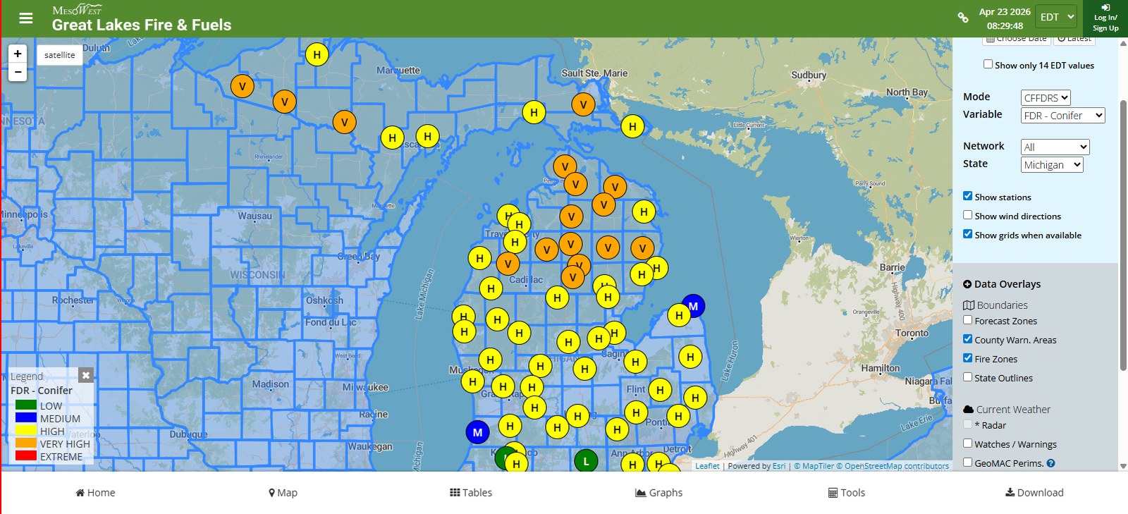
The consequences are written across our maps. The Manistee River Trail System is closed indefinitely for public safety, with washouts, landslides, and tree fall making sections impassable. The National Weather Service in Gaylord issued flood warnings on the Manistee, Pine, and Au Sable rivers. High Bridge Road between Chicago Avenue and River Road in Dickson Township — a road I drive routinely — is closed due to structural erosion. A section of the North Country Trail between those same two roads is closed indefinitely because the ground beneath it is gone. Forest Service Road 8130 is closed. Bear Creek, Rainbow Bend, and Government Landing river access sites are all inaccessible. On the Pine River, Low Bridge is out. On the Au Sable, the lower Wolf Creek trails are underwater.
At the same time, the Michigan DNR is not issuing open burn permits across much of the northern Lower Peninsula. A look at the Great Lakes Fire & Fuels portal — glff.mesowest.org — shows fine fuel dryness climbing fast. Pine needles, leaf litter, and cured grasses are drying even while the bottomlands are still draining.
And sitting on top of all of that, we still have the downed wood from the March 2026 ice storm that never got cleaned up. That fuel load isn’t going anywhere. It will cure through May and June, and by the time the first real heat wave hits, every Northern Michigan department will be staring at woods loaded like a match head.
That’s the Northern Michigan picture. It’s not unusual anymore. It’s the baseline.
“Access cuts both ways. If a wildfire starts in country where the roads have gone out, apparatus can’t get in — and civilians can’t get out.”
Why Access Is an ICS Problem, Not a Weather Problem
I run every scenario I see through the same framework I teach: the Incident Command System. Command. Operations. Planning. Logistics. Finance and Administration. When we think about wildland response, most of us default to focusing on weather, fuels, and topography. But right now, across wide swaths of rural America, the limiting factor isn’t the weather. It’s the road.
Ask yourself, as an Operations Section Chief: how do you establish a point of attack when the primary approach is closed? How do you hold a flank when your apparatus can’t cross a bridge? How do you defend structures in a drainage where the service road washed out last week?
Ask yourself, as a Logistics Section Chief: where does your water come from when your primary draft point is inaccessible? How does a tender shuttle operate when the turnaround is now a forty‑minute round trip? Where do you stage mutual aid if your traditional staging area is cut off?
Ask yourself, as a Planning Section Chief: what’s your contingency when the primary evacuation route for civilians is already closed before the fire starts?
These aren’t hypothetical exercises. They’re the questions that decide whether an incident is a contained ten‑acre grass fire or a multi‑day, multi‑agency, life‑safety event.
This Isn’t Just Northern Michigan
I want every chief, every company officer, and every engaged citizen reading this to understand something clearly: the pattern we’re living through in Manistee County is playing out coast to coast.
In December 2025, a series of atmospheric river events hit the Pacific Northwest. Rapid snowmelt combined with heavy rainfall led to widespread flooding across Washington state. Rural communities were cut off by washed‑out roads, leaving them stranded and inaccessible to emergency services. When fire season rolled in this spring, those same communities faced a drying landscape with half of their access infrastructure still awaiting repair.
In Colorado, state officials documented roughly $13.8 million in damage to public roads, culverts, and other infrastructure from historic floods that followed the 2025 wildfire season — flooding made far worse by burn scars that can no longer absorb rainfall. Then in April 2026, federal disaster declaration appeals were denied, leaving rural Coloradans to rebuild that infrastructure without the federal support they were counting on.
In the Southeast, communities from western North Carolina through east Tennessee are still rebuilding road networks lost to Hurricane Helene in 2024. Those same hills hold fire‑prone hardwood slopes that will cure this summer. If fire comes before the roads are back, crews will be working with the map they have — not the map they wish they had.
In California, the lesson was written in blood. After the Thomas Fire in 2017, debris flows in Santa Barbara County killed 21 people. Roads were impassable for weeks, at one point requiring an ad hoc ferry service between Santa Barbara and Ventura. FEMA and USGS have documented the flood‑after‑fire phenomenon across the West for more than a decade. It’s well understood, and it keeps happening.
The common thread is the compound hazard. Drought begets fire. Fire scars beget flooding. Flooding begets washouts. Washouts leave behind a degraded road network heading into the next fire season. The cycle doesn’t wait for us to catch up.
“The departments thinking about access now — before an ignition — will write shorter after‑action reports than the departments that wait.”
What Fire Service Leaders Should Be Doing This Month
This is Behind The Alarm. So let me talk about the quiet work — the work the public doesn’t see, that determines whether an incident goes well or goes sideways.
Drive your district. Personally. Not on a map. Identify the washouts, the soft shoulders, the posted bridges, the culverts that shifted in the spring flow. Note them. Share them with your officers and your mutual aid partners before the tones drop, not after.
Coordinate with your road commission. Know which county and township roads are posted for weight restrictions, and when those restrictions lift. A 54,000‑pound engine on a posted road is both a liability and a failure point.
Re‑pre‑plan your mutual aid routes with the explicit assumption that your primary route is unavailable. If your secondary route is also out, that’s a planning problem you solve today, not at 0230 on the night of the incident.
Identify alternate water supply. If your traditional drafting points are inaccessible due to flooding or bank collapse, where is your next option? Dry hydrants? Pond drafts? Portable tanks at a pre‑identified relay point? Work the math now.
Work your UTV and brush team. In terrain where an engine can’t go, a UTV with a skid unit and a trained crew may be your only option for suppression or patient contact. That capability has to be trained up now, not improvised during a call.
Brief your crews explicitly: don’t send an engine where a UTV is the right tool. That single decision saves apparatus, saves firefighter safety, and often saves the day.
Update your pre‑plans, and where possible flag known closures in your CAD system. If your neighbors are running on a bad map, the response will be bad.
What Every Property Owner and Recreational User Should Know
For the Behind The Alarm readers who aren’t on a department but care about this work: you matter to us more than you know.
Walk your own driveway. Can a Type 6 engine get down it? Can it turn around? If the answer is no, understand that a structure fire at the end of that driveway will be fought from wherever the driveway stops working — not from your front door.
Check your address sign. Reflective, visible from the road, at night, in the rain. If we can’t find you, we can’t help you.
Maintain defensible space. Thirty feet, minimum, cleared of cured fine fuels. More if you’re on a slope or surrounded by conifers.
If you recreate on federal lands, check the alerts first. Don’t put yourself into country where rescue can’t reach you. Our search and rescue partners are running thin this spring.
Carry a comms plan. Cell service is not guaranteed in our response district. A satellite messenger, a personal locator beacon, or even a pre‑arranged check‑in time can save your life.
See smoke? See fire? Call 911 immediately. Don’t assume someone else already did. I have watched fires grow from a quarter acre to ten acres in the time it took someone to decide whether to pick up the phone.
The Compound Hazard Reality
This is the era of overlapping hazards. Ice storm to flood to fire, sometimes inside a ninety‑day window. It demands that we plan differently and communicate differently. It demands that the next generation of fire service leaders think in terms of multi‑hazard response from their first day on the job.
In Stronach Township, we’re doing the work. I know my brothers and sisters across the country are doing it too. But the work is quiet, and the public mostly doesn’t see it until something goes wrong. That’s why I write Behind The Alarm. Because you — the citizen, the neighbor, the road commissioner, the township trustee — are part of this system whether you signed up for it or not. The more you understand about what we’re planning for, the more effective every one of us becomes when the tones drop.
Stay alert. Check the map. Know your route. And if you see something — say something, then call it in.
We’ll handle it from there.
— Fred R. LaPoint
Fire Chief, Stronach Township Fire Department
Behind The Alarm
Sources & Further Reading
• Huron‑Manistee National Forests Alerts, U.S. Forest Service — fs.usda.gov/r09/huron-manistee
• Michigan DNR Fire Alert — michigan.gov/dnr/firealert
• Michigan DNR Burn Permit Lookup — Michigan.gov/BurnPermit
• Great Lakes Fire & Fuels Portal — glff.mesowest.org
• National Weather Service, Gaylord, MI
• The Colorado Sun, April 2026 coverage of rural Colorado disaster declaration denials
• FEMA: Flooding After Wildfires Factsheet
• USGS: Post‑Fire Debris Flow Hazards
U.S. GAO: Wildfires — Additional Actions Needed to Address FEMA Assistance Challenges
This article first appeared in Behind The Alarm, the newsletter of Fred R. LaPoint, Fire Chief Paramedic of the Stronach Township Fire Department, on April 23, 2026. Read the original.